Welcome to the Southeast South Dakota Safe Streets for All (SS4A) Safety Action Plan project website, a central hub for learning about the effort to improve roadway safety and reduce serious and fatal crashes across the Southeast South Dakota region.
This site will be updated regularly as the project moves forward, so community members, local leaders, and partners can stay informed and involved at every step.
How to Participate
On the homepage, you will find a short project survey where you can share how you travel today, where you feel unsafe, and what safety improvements you would like to see. Your input will help shape the plan’s priorities and guide future investments in safer streets across the region.
How Your Comments Will Be Used
Comments submitted through the survey and interactive maps will be combined with crash data, roadway information, and local knowledge from agencies and stakeholders to build a comprehensive picture of safety needs in Southeast South Dakota. This community input will help identify priority projects and policy actions that can save lives and make every day travel safer and more comfortable for all users.
Community Pages and Maps
Participating communities in the Southeast South Dakota region will have its own tab on this site, featuring an interactive map you can explore. On these maps, you can zoom to specific streets, intersections, or corridors and drop a pinpoint to leave a comment describing a safety concern, a close call, or an idea for improvement.
Hot Spot Map Example
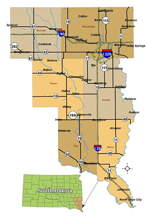
This map shows the coverage area of this regional plan in south eastern South Dakota. It includes 20 communities, including 1 county.